
Акмола topographic map
Interactive map
Click on the map to display elevation.
About this map
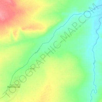
Name: Акмола topographic map, elevation, terrain.
Location: Акмола, Martuk District, Aktobe Region, Kazakhstan (50.56500 56.28665 50.61097 56.36637)
Average elevation: 212 m
Minimum elevation: 179 m
Maximum elevation: 263 m
Other topographic maps
Click on a map to view its topography, its elevation and its terrain.
Yrgyz District
Yrgyz District, Aktobe Region, 030400, Kazakhstan
Average elevation: 129 m
Mugalzhar District
Mugalzhar District, Aktobe Region, Kazakhstan
Average elevation: 279 m