
Höllmannsried topographic map
Interactive map
Click on the map to display elevation.
About this map
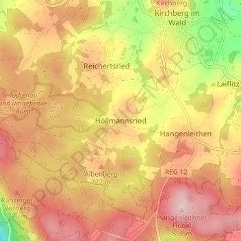
Name: Höllmannsried topographic map, elevation, terrain.
Average elevation: 702 m
Minimum elevation: 541 m
Maximum elevation: 807 m
Other topographic maps
Click on a map to view its topography, its elevation and its terrain.
Tafertsried
Deutschland > Bayern > Landkreis Regen > Weihmannsried
Tafertsried, Weihmannsried, Gotteszell, Ruhmannsfelden (VGem), Landkreis Regen, Bayern, 94250, Deutschland
Average elevation: 649 m
Regen
Deutschland > Bayern > Landkreis Regen
Regen, Landkreis Regen, Bayern, 94209, Deutschland
Average elevation: 627 m