
Regen topographic map
Interactive map
Click on the map to display elevation.
Regen
1917 kam das Dorf Heilig-Geist mit rund 110 Einwohnern zu Regen. Am 1. April 1962 fiel die Gemeinde Bärndorf an die Stadt Regen, wodurch die Einwohnerzahl auf 6500 anstieg. Am 1. April 1964 folgten Neigerhöhe, Riedham, Wieshof und Huberhof, die zuvor zur Gemeinde Rinchnachmündt gehörten. Am 1. Juli 1964 kam die Gemeinde Eggenried mit 1260 ha und 584 Einwohnern hinzu. Im Zuge der Gemeindegebietsreform folgten am 1. Januar 1972 die Gemeinde Oberneumais mit 505 Einwohnern und 1241 ha Gemeindefläche sowie am 1. Mai 1978 die Gemeinde Rinchnachmündt mit 1181 ha und 939 Einwohnern und die Gemeinde March mit 1038 ha und 743 Einwohnern.
About this map
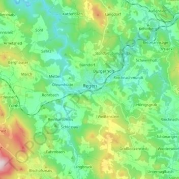
Name: Regen topographic map, elevation, terrain.
Location: Regen, Landkreis Regen, Bayern, 94209, Deutschland (48.92464 13.04719 49.01067 13.21199)
Average elevation: 627 m
Minimum elevation: 487 m
Maximum elevation: 1,013 m
Other topographic maps
Click on a map to view its topography, its elevation and its terrain.