Geolocate

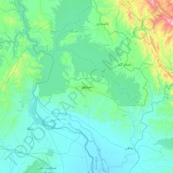
Mirpur topographic map

Click on the map to display elevation.

Mirpur

Mirpur lies at the foothills of the Himalayas mountain range of an altitude of 648 metres or 2,126 feet above sea level and is linked with the main Peshawar-Lahore Grand Trunk Road at Dina Tehsil. It is the headquarters of Mirpur District, which has two subdivisions: Mirpur and Dudial. Mirpur is now one of the largest city of Azad Kashmir. The building of the new city in late 1960s paved the way for New Mirpur, situated on the bank of Mangla Lake.

Wikipedia (CC-BY-SA 3.0)

About this map

Name: Mirpur topographic map, elevation, terrain.

Location: Mirpur, Mirpur Tehsil, Mirpur District, Mirpur Division, Azad Kashmir, 10250, Pakistan (32.98864 73.58821 33.30864 73.90821)

Average elevation: 377 m

Minimum elevation: 228 m

Maximum elevation: 1,280 m

Gear up for your next adventure:

🧥Breathable Waterproof Jackets - Essential rain protection for the unpredictable British climate
📦Dry Bags - Waterproof bags to protect gear from rain
🥾Hiking Boot Waterproofing Wax - Maintain the lifespan of your leather trekking boots
🌦️Portable Weather Meters - Handheld tools for monitoring weather conditions
🔥Emergency Fire Starters - Reliable ignition tools for survival situations in damp conditions

As an Amazon Associate, this site earns from qualifying purchases at no extra cost to you.