Geolocate

Chehalis topographic map

Interactive map

Click on the map to display elevation.

About this map

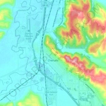
Name: Chehalis topographic map, elevation, terrain.

Location: Chehalis, Lewis County, Washington, United States (46.63377 -122.99761 46.69447 -122.92950)

Average elevation: 81 m

Minimum elevation: 45 m

Maximum elevation: 198 m

Other topographic maps

Click on a map to view its topography, its elevation and its terrain.

Glenoma

United States > Washington > Lewis County

Average elevation: 354 m

Bunker

United States > Washington > Lewis County

Average elevation: 101 m

Mayfield

United States > Washington > Lewis County

Average elevation: 223 m

Packwood

United States > Washington > Lewis County

Average elevation: 379 m

Randle

United States > Washington > Lewis County

Average elevation: 378 m

Ceres

United States > Washington > Lewis County

Average elevation: 123 m

Ham Hill

United States > Washington > Lewis County > Centralia

Average elevation: 101 m

Randle

United States > Washington > Lewis County

Average elevation: 378 m

The Rockies

United States > Washington > Lewis County

Average elevation: 1,012 m

Onalaska

United States > Washington > Lewis County

Average elevation: 170 m