
Make a donation
Gear up for your next adventure:
As an Amazon Associate, this site earns from qualifying purchases at no extra cost to you.
The Rockies topographic map
Click on the map to display elevation.
Make a donation
Gear up for your next adventure:
As an Amazon Associate, this site earns from qualifying purchases at no extra cost to you.
About this map
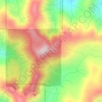
Name: The Rockies topographic map, elevation, terrain.
Location: The Rockies, Lewis County, Washington, United States (46.65645 -122.36377 46.65655 -122.36367)
Average elevation: 1,012 m
Minimum elevation: 699 m
Maximum elevation: 1,283 m
Make a donation
Gear up for your next adventure:
As an Amazon Associate, this site earns from qualifying purchases at no extra cost to you.
Other topographic maps
Click on a map to view its topography, its elevation and its terrain.
Make a donation
Gear up for your next adventure:
As an Amazon Associate, this site earns from qualifying purchases at no extra cost to you.
Winlock
United States > Washington > Lewis County
The eastern edge of the Willapa Hills lie to the west. To the east are relatively flat prairies. A notable landmark about four miles west of town is Sam Henry Mountain, elevation 1,492 feet (455 m), named for an early section superintendent of the Northern Pacific Railroad. Mt. St. Helens, about forty miles…
Average elevation: 124 m
Make a donation
Gear up for your next adventure:
As an Amazon Associate, this site earns from qualifying purchases at no extra cost to you.
Make a donation
Gear up for your next adventure:
As an Amazon Associate, this site earns from qualifying purchases at no extra cost to you.
Make a donation
Gear up for your next adventure:
As an Amazon Associate, this site earns from qualifying purchases at no extra cost to you.
Napavine
United States > Washington > Lewis County
A railroad depot was built in the late 1910s and provided passenger service until 1960. The Napavine Depot continued to serve the area until the station was permanently closed in April 1968 despite local protest. The Northern Pacific Railway station marked the highest elevation on the line between Portland and…
Average elevation: 105 m