Isla Yallis topographic map
Interactive map
Click on the map to display elevation.
About this map

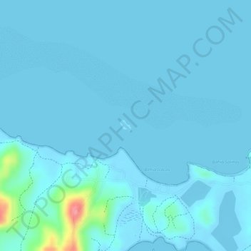
Name: Isla Yallis topographic map, elevation, terrain.
Location: Isla Yallis, Puerto Rico, United States (18.14738 -65.30906 18.14862 -65.30781)
Average elevation: 7 m
Minimum elevation: -1 m
Maximum elevation: 93 m
Other topographic maps
Click on a map to view its topography, its elevation and its terrain.

Puerto Rico
The island is mostly mountainous with large coastal areas in the north and south. The main mountain range is called "La Cordillera Central" (The Central Range). The highest elevation in Puerto Rico, Cerro de Punta 4,390 feet (1,340 m), is located in this range.
Average elevation: 65 m

San Juan
As with other parts of Puerto Rico and the Caribbean, San Juan is often blanketed by waves of Saharan dust coming from the Sahara across the Atlantic Ocean in Northern Africa. Although beneficial to the tropical environment, these dust storms have recently become hazardous to human health causing haze and…
Average elevation: 59 m

Yabucoa
The municipality of Yabucoa is located in the south-eastern coast of Puerto Rico. The Valley of Yabucoa is surrounded by the hills of the San Lorenzo Batholith on three sides and by the Caribbean Sea on the fourth. The hills surrounding the Yabucoa Valley as well as the bedrock underlying the alluvium in the…
Average elevation: 147 m

Patillas
Patillas is located on the southeastern coast. Despite being located in the region known as the Coast Valley of the South, a part of the town is mountainous. The Sierra de Cayey borders the town's territory through the northern region, and the Sierra de Guardarraya through the east. The city is located in USDA…
Average elevation: 282 m

Isla de Culebra
United States > Puerto Rico > Culebra > Culebra
Culebra is characterized by an irregular topography resulting in a long intricate shoreline. The island is approximately 7 by 5 miles (11 by 8 km). The coast is marked by cliffs, sandy coral beaches and mangrove forests. Inland, the tallest point on the island is Mount Resaca, with an elevation of 636 feet…
Average elevation: 11 m

Gozalandia Waterfall
United States > Puerto Rico > San Sebastián > San Sebastián
Average elevation: 176 m

Maunabo
Maunabo is surrounded by high mountains on two sides. The three major peaks are Pico Hutton on Sierra de Guardarraya with an elevation of 1,799 feet (548 m); Cerro Santa Elena also known as El Sombrerito (the "little hat" for its unusual shape) on Sierra Pandura with an elevation of 1,722 feet (525 m); and…
Average elevation: 104 m

Culebra
Culebra is characterized by an irregular topography resulting in a long intricate shoreline. The island is approximately 7 by 5 miles (11 by 8 km). The coast is marked by cliffs, sandy coral beaches and mangrove forests. Inland, the tallest point on the island is Mount Resaca, with an elevation of 636 feet…
Average elevation: 4 m

Yabucoa
The municipality of Yabucoa is located in the south-eastern coast of Puerto Rico. The Valley of Yabucoa is surrounded by the hills of the San Lorenzo Batholith on three sides and by the Caribbean Sea on the fourth. The hills surrounding the Yabucoa Valley as well as the bedrock underlying the alluvium in the…
Average elevation: 119 m

Dorado
Dorado is located in Puerto Rico's Northern Karst region. Much of its geology consists of alluvial and coastal/estuarine sediments of Quaternary age and limestones of Tertiary age. The limestones are mostly in the south part of the municipality, in Espinosa, Maguayo and Rio Lajas barrios. These limestones…
Average elevation: 33 m

Camuy
Camuy belongs to the zone designated as the plateau of the northwest where the terrain is level and known as the Valley of Quebradillas. It is located in the Northern Karst zone of Puerto Rico. In the interior of the municipality the topography becomes very irregular near Cibao. This strip of land, a zone of…
Average elevation: 178 m

Utuado
During the late 18th and early 19th centuries, Utuado's population continued to grow as coffee gained in importance and growers saw the need for high altitudes and mountainous terrain to produce the best coffee beans. People not only migrated from the Puerto Rican coastal towns but also from Ireland (founder…
Average elevation: 481 m

Dorado
Dorado is located in Puerto Rico's Northern Karst region. Much of its geology consists of alluvial and coastal/estuarine sediments of Quaternary age and limestones of Tertiary age. The limestones are mostly in the south part of the municipality, in Espinosa, Maguayo and Rio Lajas barrios. These limestones…
Average elevation: 33 m

San Juan
As with other parts of Puerto Rico and the Caribbean, San Juan is often blanketed by waves of Saharan dust coming from the Sahara across the Atlantic Ocean in Northern Africa. Although beneficial to the tropical environment, these dust storms have recently become hazardous to human health causing haze and…
Average elevation: 59 m

Mayagüez
United States > Puerto Rico > Mayagüez
Mayagüez has a tropical monsoon climate (Köppen climate classification Am). The city has the most extreme weather of the island. The high frequency of severe storms in the summer can produce strong winds, floods, waterspouts, and sometimes hail and even tornadoes. The average annual temperature is 75 °F (24…
Average elevation: 93 m

Toa Baja
The elevations range from 200 to 490 feet (60 to 150 meters) above sea level, with most of its highest parts located in the south. The rest of the area is mostly plain. The northern part of Toa Baja is characterized for its mangroves and marshes, while the southern part is classified as typical karst area.
Average elevation: 32 m

Florida
United States > Puerto Rico > Florida
Economic prosperity in the 1920s stimulated tourism to Florida and related development of hotels and resort communities. Combined with its sudden elevation in profile was the Florida land boom of the 1920s, which brought a brief period of intense land development. In 1925, the Seaboard Air Line broke the FEC's…
Average elevation: 198 m

Ponce
Elevations include Cerro de Punta at 4,390 feet (1,338 m), the highest in Puerto Rico, located in Barrio Anón in the territory of the municipality of Ponce. Mount Jayuya, at 4,314 feet (1,315 m) is located on the boundary between Barrio Anón and Barrio Saliente in Jayuya. Cerro Maravilla, at nearly 3,970…
Average elevation: 211 m

Cerro de Punta
United States > Puerto Rico > Ponce
The mountain is part of the Cordillera Central and is located on the border between the municipalities of Jayuya and Ponce. The access road to the point closest to the highest elevation is from the municipality of Jayuya. It is part of the Toro Negro Forest Reserve, and it has been described as "an alpine…
Average elevation: 1,021 m

Cayey
United States > Puerto Rico > Cayey
Cayey's climate is humid, rainy and mild compared to lower-elevation areas of the island, the area of the town is nearly 1,500 feet (460 m) high, so the climate is subtropical high. In summer average high Temperatures are around 82 °F to 88 °F and 70 °F to 78 °F in winter, and low around 68 °F to 72 °F…
Average elevation: 489 m

Utuado
During the late 18th and early 19th centuries, Utuado's population continued to grow as coffee gained in importance and growers saw the need for high altitudes and mountainous terrain to produce the best coffee beans. People not only migrated from the Puerto Rican coastal towns but also from Ireland (founder…
Average elevation: 481 m

San Juan
As with other parts of Puerto Rico and the Caribbean, San Juan is often blanketed by waves of Saharan dust coming from the Sahara across the Atlantic Ocean in Northern Africa. Although beneficial to the tropical environment, these dust storms have recently become hazardous to human health causing haze and…
Average elevation: 59 m

Aibonito
Aibonito is located at a relatively high elevation (its main square is the highest in the island at 2,401 ft [731 m] above sea level), which makes its climate cooler than most of Puerto Rico's towns.
Average elevation: 515 m

Guayanilla
Guayanilla is located on the southern coast. The coastline forms the Guayanilla Bay, one of the best natural harbors in Puerto Rico, to the south, also. The nearest city is Ponce, which is 12 miles (19 km) to the east. The northern regions are bordered by mountains that reach 3,300 feet (1,000 m) at the…
Average elevation: 238 m

Ponce
Elevations include Cerro de Punta at 4,390 feet (1,338 m), the highest in Puerto Rico, located in Barrio Anón in the territory of the municipality of Ponce. Mount Jayuya, at 4,314 feet (1,315 m) is located on the boundary between Barrio Anón and Barrio Saliente in Jayuya. Cerro Maravilla, at nearly 3,970…
Average elevation: 211 m

Mayagüez
Mayagüez has a tropical savanna climate (Köppen climate classification Aw). The city has the most extreme weather of the island. The high frequency of severe storms in the summer can produce strong winds, floods, waterspouts, and sometimes hail and even tornadoes. The average annual temperature is 75 °F or…
Average elevation: 75 m

Adjuntas
Adjuntas features a tropical rainforest climate that borders on a subtropical highland climate. While the town technically features a tropical rainforest climate, due to its high elevation, the climate is noticeably cooler than the norm for this climate category. Summers are warm (83°-85 °F) in the daytime…
Average elevation: 604 m

San Juan
As with other parts of Puerto Rico and the Caribbean, San Juan is often blanketed by waves of Saharan dust coming from the Sahara across the Atlantic Ocean in Northern Africa. Although beneficial to the tropical environment, these dust storms have recently become hazardous to human health causing haze and…
Average elevation: 59 m

Culebra
United States > Puerto Rico > Culebra > Culebra
Culebra is characterized by an irregular topography resulting in a long intricate shoreline. The island is approximately 7 by 5 miles (11 by 8 km). The coast is marked by cliffs, sandy coral beaches and mangrove forests. Inland, the tallest point on the island is Mount Resaca, with an elevation of 636 ft…
Average elevation: 16 m