Geolocate

Treorchy topographic map

Click on the map to display elevation.

About this map

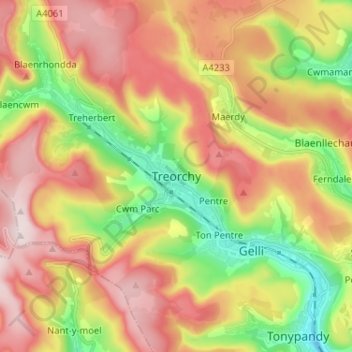
Name: Treorchy topographic map, elevation, terrain.

Location: Treorchy, Rhondda Cynon Taf, Wales, CF42 6RG, United Kingdom (51.62106 -3.54415 51.70106 -3.46415)

Average elevation: 342 m

Minimum elevation: 123 m

Maximum elevation: 560 m

Rhondda Cynon Taf trails, hiking, mountain biking, running and outdoor activities

Other topographic maps

Click on a map to view its topography, its elevation and its terrain.

Mid Glamorgan

United Kingdom > Wales > Rhondda Cynon Taf

Average elevation: 235 m

Pontypridd

United Kingdom > Wales > Rhondda Cynon Taf

Average elevation: 183 m

Penrhiwceiber

United Kingdom > Wales > Rhondda Cynon Taf

Average elevation: 229 m

Pontypridd

United Kingdom > Wales > Rhondda Cynon Taf

Average elevation: 183 m

Trealaw

United Kingdom > Wales > Rhondda Cynon Taf > Tonypandy

Average elevation: 222 m

Gear up for your next adventure:

🧴Sport Sunscreen Sticks - High-protection sunblock that won't run into your eyes on the trail
👕Technical Hiking Tees - Moisture-management for high-exertion climbs
🧣Neck Gaiters - Versatile protection against wind and cold
📕Outdoor Navigation Books - Learn traditional and modern navigation techniques
🧺Microfibre Travel Towels - Fast-drying and compact towels for wild swimming and camping

As an Amazon Associate, this site earns from qualifying purchases at no extra cost to you.