Geolocate

Chirk topographic map

Click on the map to display elevation.

About this map

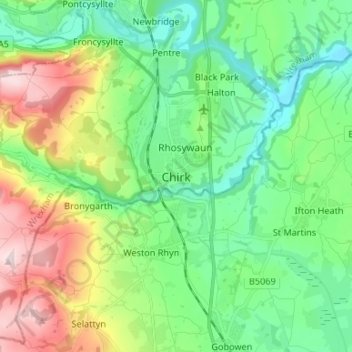
Name: Chirk topographic map, elevation, terrain.

Location: Chirk, Wrexham, Wales, LL14 5EZ, United Kingdom (52.89201 -3.09639 52.97201 -3.01639)

Average elevation: 147 m

Minimum elevation: 34 m

Maximum elevation: 399 m

Wrexham trails, hiking, mountain biking, running and outdoor activities

Other topographic maps

Click on a map to view its topography, its elevation and its terrain.

Penycae

United Kingdom > Wales > Wrexham

Average elevation: 350 m

Rhosddu

United Kingdom > Wales > Wrexham

Average elevation: 88 m

Gwersyllt

United Kingdom > Wales > Wrexham

Average elevation: 112 m

Bangor-on-Dee

United Kingdom > Wales > Wrexham

Average elevation: 30 m

Cefn

United Kingdom > Wales > Wrexham > Acrefair

Average elevation: 142 m

Gear up for your next adventure:

🔥Reusable Hand Warmers - Maintain dexterity in your fingers for precise map handling
🛰️Outdoor GPS Navigation - Navigation devices for remote and off-grid areas
📷Outdoor Action Cameras - Cameras designed for hiking and adventure
🛰️Handheld GPS Devices - Reliable GPS units for hiking and outdoor navigation
🕶️Glacier Goggles - Maximum protection for high-altitude snow topography

As an Amazon Associate, this site earns from qualifying purchases at no extra cost to you.