
Make a donation
Gear up for your next adventure:
As an Amazon Associate, this site earns from qualifying purchases at no extra cost to you.
Nea Makri Municipal Unit topographic map
Click on the map to display elevation.
Make a donation
Gear up for your next adventure:
As an Amazon Associate, this site earns from qualifying purchases at no extra cost to you.
About this map
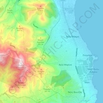
Name: Nea Makri Municipal Unit topographic map, elevation, terrain.
Average elevation: 217 m
Minimum elevation: 0 m
Maximum elevation: 777 m
Make a donation
Gear up for your next adventure:
As an Amazon Associate, this site earns from qualifying purchases at no extra cost to you.
Other topographic maps
Click on a map to view its topography, its elevation and its terrain.
Astypalaia
Greece > Attica > Regional Unit of East Attica > Anavissos Municipal Unit
Average elevation: 10 m
Make a donation
Gear up for your next adventure:
As an Amazon Associate, this site earns from qualifying purchases at no extra cost to you.
Christoupoli
Greece > Attica > Regional Unit of East Attica > Spata-Loutsa Municipal Unit
Average elevation: 122 m
Ανάβυσσος
Greece > Attica > Regional Unit of East Attica > Anavissos Municipal Unit
Average elevation: 91 m
Make a donation
Gear up for your next adventure:
As an Amazon Associate, this site earns from qualifying purchases at no extra cost to you.
Artemida
Greece > Attica > Regional Unit of East Attica > Artemida Municipal Unit
Average elevation: 38 m