
Lily topographic map
Interactive map
Click on the map to display elevation.
About this map
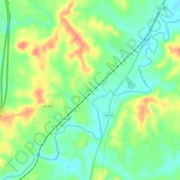
Name: Lily topographic map, elevation, terrain.
Location: Lily, Laurel County, Kentucky, 40740, United States (37.00459 -84.09489 37.04459 -84.05489)
Average elevation: 350 m
Minimum elevation: 325 m
Maximum elevation: 389 m
Other topographic maps
Click on a map to view its topography, its elevation and its terrain.
Hopewell
United States > Kentucky > Laurel County
Hopewell, Laurel County, Kentucky, 40737, United States
Average elevation: 358 m
Keavy
United States > Kentucky > Laurel County > Keavy
Keavy, Laurel County, Kentucky, 40737, United States
Average elevation: 363 m
Cane Creek
United States > Kentucky > Laurel County > Cane Creek
Cane Creek, Laurel County, Kentucky, United States
Average elevation: 377 m
London
United States > Kentucky > Laurel County
London, Laurel County, Kentucky, 40741, United States
Average elevation: 370 m