
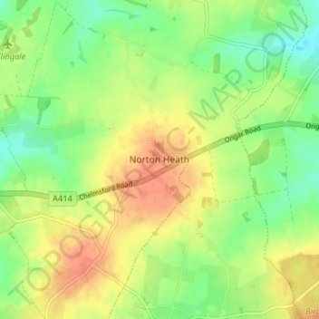
Norton Heath topographic map
Interactive map
Click on the map to display elevation.
About this map
Name: Norton Heath topographic map, elevation, terrain.
Average elevation: 80 m
Minimum elevation: 58 m
Maximum elevation: 103 m
Other topographic maps
Click on a map to view its topography, its elevation and its terrain.
Roydon
United Kingdom > England > Essex > Epping Forest
Roydon, Epping Forest, Essex, England, United Kingdom
Average elevation: 48 m
Lower Sheering
United Kingdom > England > Essex > Epping Forest
Lower Sheering, Epping Forest, Essex, England, CM21 9LQ, United Kingdom
Average elevation: 65 m
Chigwell Row
United Kingdom > England > Essex > Epping Forest
Chigwell Row, Epping Forest, Essex, England, IG7 6DB, United Kingdom
Average elevation: 59 m
Lower Nazeing
United Kingdom > England > Essex > Epping Forest
Lower Nazeing, Epping Forest, Essex, England, EN9 2LA, United Kingdom
Average elevation: 43 m
Epping Forest
United Kingdom > England > Essex > Epping Forest > Debden Green
Epping Forest, Debden Green, Epping Forest, Essex, England, United Kingdom
Average elevation: 77 m
Abbess Roding
United Kingdom > England > Essex > Epping Forest
Abbess Roding, Epping Forest, Essex, England, CM5 0PA, United Kingdom
Average elevation: 73 m
Stonards Hill
United Kingdom > England > Essex > Epping Forest
Stonards Hill, Epping Forest, Essex, England, CM16 7QH, United Kingdom
Average elevation: 87 m
Stanford Rivers
United Kingdom > England > Essex > Epping Forest > Stanford Rivers
Stanford Rivers, Epping Forest, Essex, England, United Kingdom
Average elevation: 65 m
Theydon Garnon
United Kingdom > England > Essex > Epping Forest
Theydon Garnon, Epping Forest, Essex, England, United Kingdom
Average elevation: 71 m
Chipping Ongar
United Kingdom > England > Essex > Epping Forest
Chipping Ongar, Epping Forest, Essex, England, CM5 9EY, United Kingdom
Average elevation: 68 m
Waltham Abbey
United Kingdom > England > Essex > Epping Forest
Waltham Abbey, Epping Forest, Essex, England, United Kingdom
Average elevation: 44 m
High Beach
United Kingdom > England > Essex > Epping Forest
High Beach, Waltham Abbey, Epping Forest, Essex, England, IG10 4AD, United Kingdom
Average elevation: 74 m
Nazeing
United Kingdom > England > Essex > Epping Forest > Tylers Cross
Nazeing, Tylers Cross, Epping Forest, Essex, England, United Kingdom
Average elevation: 62 m
Gunpowder Park
United Kingdom > England > Essex > Epping Forest
Gunpowder Park, Waltham Abbey, Epping Forest, Essex, England, EN9 3GP, United Kingdom
Average elevation: 24 m
Epping Forest
United Kingdom > England > Essex > Epping Forest
Epping Forest, London Borough of Waltham Forest, Epping Forest, Essex, Greater London, England, United Kingdom
Average elevation: 44 m
Fyfield
United Kingdom > England > Essex > Epping Forest > Fyfield
Fyfield, Epping Forest, Essex, England, United Kingdom
Average elevation: 68 m
How Green
United Kingdom > England > Essex > Epping Forest > Stapleford Abbotts
How Green, Stapleford Abbotts, Epping Forest, Essex, England, RM4 1EG, United Kingdom
Average elevation: 63 m
Lambourne
United Kingdom > England > Essex > Epping Forest > Abridge
Lambourne, Abridge, Epping Forest, Essex, England, United Kingdom
Average elevation: 56 m
Shelley
United Kingdom > England > Essex > Epping Forest > Chipping Ongar
Shelley, Ongar, Chipping Ongar, Epping Forest, Essex, England, CM5 0HQ, United Kingdom
Average elevation: 58 m
Epping
United Kingdom > England > Essex > Epping Forest > Ivy Chimneys
Epping, Ivy Chimneys, Epping Forest, Essex, England, United Kingdom
Average elevation: 84 m
Steward's Green
United Kingdom > England > Essex > Epping Forest > Coopersale Street > Steward's Green
Steward's Green, Epping, Coopersale Street, Epping Forest, Essex, East of England, England, CM16 7PD, United Kingdom
Average elevation: 76 m
Hangman's Hill
United Kingdom > England > Essex > Epping Forest > Loughton
Hangman's Hill, Waltham Abbey, Loughton, Epping Forest, Essex, East of England, England, EN9 3QW, United Kingdom
Average elevation: 64 m
Sewardstonebury
United Kingdom > England > Essex > Epping Forest > Sewardstonebury
Sewardstonebury, Epping Forest, Essex, East of England, England, E4 7QS, United Kingdom
Average elevation: 51 m
Chigwell
United Kingdom > England > Essex > Epping Forest
Chigwell, Epping Forest, Essex, England, United Kingdom
Average elevation: 43 m
Upshire
United Kingdom > England > Essex > Epping Forest > Upshire
Upshire, Waltham Abbey, Epping Forest, Essex, East of England, England, EN9 3SW, United Kingdom
Average elevation: 61 m
Little Laver
United Kingdom > England > Essex > Epping Forest
Little Laver, Epping Forest, Essex, East of England, England, United Kingdom
Average elevation: 80 m
Thornwood Common
United Kingdom > England > Essex > Epping Forest > Thornwood Common
Thornwood Common, Epping Forest, Essex, England, CM16 6NR, United Kingdom
Average elevation: 89 m
Moreton
United Kingdom > England > Essex > Epping Forest > Moreton
Moreton, Epping Forest, Essex, England, United Kingdom
Average elevation: 70 m
Chipping Ongar
United Kingdom > England > Essex > Epping Forest > Chipping Ongar
Chipping Ongar, Epping Forest, Essex, England, CM5 9BW, United Kingdom
Average elevation: 68 m
Greensted
United Kingdom > England > Essex > Epping Forest
Greensted, Epping Forest, Essex, England, CM5 9LD, United Kingdom
Average elevation: 62 m
Hastingwood
United Kingdom > England > Essex > Epping Forest
Hastingwood, Epping Forest, Essex, England, CM17 9JX, United Kingdom
Average elevation: 87 m
Abridge
United Kingdom > England > Essex > Epping Forest
Abridge, Epping Forest, Essex, England, RM4 1BB, United Kingdom
Average elevation: 48 m
Matching Green
United Kingdom > England > Essex > Epping Forest
Matching Green, Epping Forest, Essex, England, CM17 0PR, United Kingdom
Average elevation: 80 m
Nazeing
United Kingdom > England > Essex > Epping Forest > Nazeing > Nazeing
Nazeing, Epping Forest, Essex, East of England, England, EN9 2DD, United Kingdom
Average elevation: 63 m