
Make a donation
Gear up for your next adventure:
As an Amazon Associate, this site earns from qualifying purchases at no extra cost to you.
El Dorado topographic map
Click on the map to display elevation.
Make a donation
Gear up for your next adventure:
As an Amazon Associate, this site earns from qualifying purchases at no extra cost to you.
El Dorado
Altitud de la cabecera municipal (metros sobre el nivel del mar): 500 m s. n. m. Temperatura media: 26 °C.
Make a donation
Gear up for your next adventure:
As an Amazon Associate, this site earns from qualifying purchases at no extra cost to you.
About this map
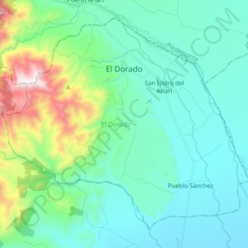
Name: El Dorado topographic map, elevation, terrain.
Location: El Dorado, Ariari, Meta, Colombia (3.64985 -73.90323 3.76724 -73.76510)
Average elevation: 649 m
Minimum elevation: 395 m
Maximum elevation: 1,682 m
Make a donation
Gear up for your next adventure:
As an Amazon Associate, this site earns from qualifying purchases at no extra cost to you.
Other topographic maps
Click on a map to view its topography, its elevation and its terrain.