
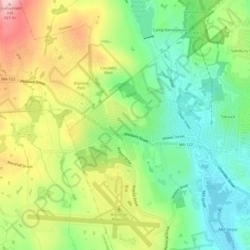
West Tatnuck topographic map
Interactive map
Click on the map to display elevation.
About this map
Name: West Tatnuck topographic map, elevation, terrain.
Average elevation: 266 m
Minimum elevation: 159 m
Maximum elevation: 425 m
Other topographic maps
Click on a map to view its topography, its elevation and its terrain.
Greendale
United States > Massachusetts > Worcester County > Worcester
Greendale, Worcester, Worcester County, Massachusetts, 01606, United States
Average elevation: 188 m
Union Hill
United States > Massachusetts > Worcester County > Worcester
Union Hill, Worcester, Worcester County, Massachusetts, 01655, United States
Average elevation: 163 m
Jamesville
United States > Massachusetts > Worcester County > Worcester
Jamesville, Worcester, Worcester County, Massachusetts, 01611, United States
Average elevation: 197 m
Lakeview
United States > Massachusetts > Worcester County > Worcester
Lakeview, Worcester, Worcester County, Massachusetts, 01604, United States
Average elevation: 146 m
North Worcester
United States > Massachusetts > Worcester County > Worcester
North Worcester, Worcester, Worcester County, Massachusetts, 01606, United States
Average elevation: 216 m
Sunderland
United States > Massachusetts > Worcester County > Worcester
Sunderland, Worcester, Worcester County, Massachusetts, 01604, United States
Average elevation: 154 m
Hammond Heights
United States > Massachusetts > Worcester County > Worcester
Hammond Heights, Worcester, Worcester County, Massachusetts, 01609, United States
Average elevation: 173 m
Hadwen Arboretum
United States > Massachusetts > Worcester County > Worcester > Main South
Hadwen Arboretum, 950, Main Street, Main South, Worcester, Worcester County, Massachusetts, 01610, United States
Average elevation: 165 m
Swan Avenue
United States > Massachusetts > Worcester County > Worcester > Swan Avenue
Swan Avenue, Worcester, Worcester County, Massachusetts, 01602, United States
Average elevation: 198 m
Summit
United States > Massachusetts > Worcester County > Worcester > Summit
Summit, Worcester, Worcester County, Massachusetts, 01606, United States
Average elevation: 199 m
College Hill
United States > Massachusetts > Worcester County > Worcester > College Hill
College Hill, Worcester, Worcester County, Massachusetts, 01607, United States
Average elevation: 158 m