
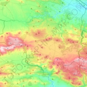
Δημοτική Ενότητα Δερβενοχωρίων topographic map
Interactive map
Click on the map to display elevation.
About this map
Name: Δημοτική Ενότητα Δερβενοχωρίων topographic map, elevation, terrain.
Average elevation: 417 m
Minimum elevation: 62 m
Maximum elevation: 1,011 m
Other topographic maps
Click on a map to view its topography, its elevation and its terrain.
Σκροπονέρια Βοιωτίας
Greece > Thessaly and Central Greece > Regional Unit of Boeotia > Municipal Unit of Akrefnia
Average elevation: 239 m
Levadia Municipal Unit
Greece > Thessaly and Central Greece > Regional Unit of Boeotia
Average elevation: 468 m
Livadia
Greece > Thessaly and Central Greece > Regional Unit of Boeotia > Levadia Municipal Unit
Average elevation: 313 m
Pyli
Greece > Thessaly and Central Greece > Regional Unit of Boeotia > Δημοτική Ενότητα Δερβενοχωρίων
Average elevation: 574 m
Cheronia
Greece > Thessaly and Central Greece > Regional Unit of Boeotia > Cheronia
Average elevation: 147 m
Arachova
Greece > Thessaly and Central Greece > Regional Unit of Boeotia > Δημοτική Ενότητα Αραχώβης > Arachova
Arachova is situated at about a 970 m (3182 ft) elevation on the southern slope of Mount Parnassus, above the valley of the river Pleistos. The municipal unit has an area of 139.448 km2. Arachova is located 8 km E of Delphi, 9 km northwest of Distomo, 18 km southeast of Amfissa and 26 km west of Livadeia. The…
Average elevation: 901 m
Tanagra
Greece > Thessaly and Central Greece > Regional Unit of Boeotia > Δημοτική Ενότητα Τανάγρας > Tanagra
Average elevation: 231 m