Geolocate

Marabut topographic map

Click on the map to display elevation.

About this map

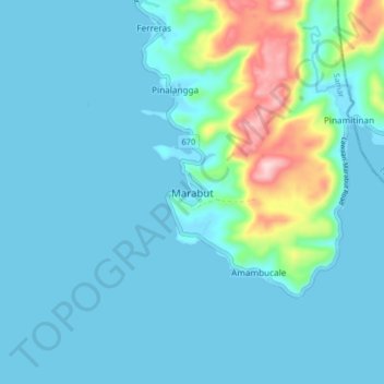
Name: Marabut topographic map, elevation, terrain.

Location: Marabut, Samar, Eastern Visayas, Philippines (11.06759 125.17254 11.14759 125.25254)

Average elevation: 37 m

Minimum elevation: -1 m

Maximum elevation: 263 m

Other topographic maps

Click on a map to view its topography, its elevation and its terrain.

Daram Island

Philippines > Samar > Daram

Average elevation: 21 m

Marabut

Philippines > Samar

Average elevation: 83 m

Gandara

Philippines > Samar > Gandara

Average elevation: 126 m

Calbayog

Philippines > Samar

Average elevation: 78 m

Gear up for your next adventure:

🧺Mesh Stuff Sacks - Breathable storage for wet gear or camp organization
🧦Merino Wool Hiking Socks - Moisture-wicking socks to prevent blisters during long mountain walks
🥾Trekking Poles - Poles to improve stability on uneven terrain
🗺️Ordnance Survey Maps - Official UK maps for walking and outdoor activities
📐Altimeters & Barometers - Tools for measuring altitude and air pressure

As an Amazon Associate, this site earns from qualifying purchases at no extra cost to you.