Geolocate

Marabut topographic map

Click on the map to display elevation.

About this map

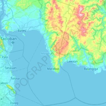
Name: Marabut topographic map, elevation, terrain.

Location: Marabut, Samar, Eastern Visayas, 6721, Philippines (10.93836 125.09500 11.41778 125.31585)

Average elevation: 83 m

Minimum elevation: -1 m

Maximum elevation: 703 m

Other topographic maps

Click on a map to view its topography, its elevation and its terrain.

Brgy. Sto.Niño

Philippines > Samar > Marabut

Average elevation: 50 m

Payao

Philippines > Samar > Catbalogan

Average elevation: 45 m

Logero

Philippines > Samar > Marabut

Average elevation: 33 m

Catbalogan

Philippines > Samar

Average elevation: 60 m

Canlapwas

Philippines > Samar > Catbalogan

Average elevation: 81 m

Maqueda Bay

Philippines > Samar > Paranas

Average elevation: 0 m

Villareal Bay

Philippines > Samar

Average elevation: 0 m

Beri

Philippines > Samar > San Jorge

Average elevation: 268 m

Blanca Aurora

Philippines > Samar > San Jorge

Average elevation: 46 m

Basey

Philippines > Samar

Average elevation: 2 m

Marabut

Philippines > Samar

Average elevation: 37 m

Villareal

Philippines > Samar

Average elevation: 15 m

Matuguinao

Philippines > Samar > Matuguinao

Average elevation: 167 m

Gear up for your next adventure:

🔦LED Camping Lanterns - Illumination for reading maps inside your tent at night
🗺️Topographic Maps - Detailed maps showing elevation and terrain features
📻Hand-Crank Emergency Radios - Stay updated on weather warnings in remote areas
🥾Hiking Boot Waterproofing Wax - Maintain the lifespan of your leather trekking boots
🛌Insulated Sleeping Mats - Crucial thermal protection when sleeping on cold, uneven ground

As an Amazon Associate, this site earns from qualifying purchases at no extra cost to you.