Geolocate

Basey topographic map

Click on the map to display elevation.

About this map

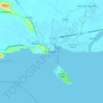
Name: Basey topographic map, elevation, terrain.

Location: Basey, Samar, Eastern Visayas, Philippines (11.24022 125.02913 11.32022 125.10913)

Average elevation: 2 m

Minimum elevation: 0 m

Maximum elevation: 65 m

Other topographic maps

Click on a map to view its topography, its elevation and its terrain.

Daram Island

Philippines > Samar > Daram

Average elevation: 21 m

Marabut

Philippines > Samar

Average elevation: 83 m

Gandara

Philippines > Samar > Gandara

Average elevation: 126 m

Calbayog

Philippines > Samar

Average elevation: 78 m

Gear up for your next adventure:

🎒Backpack Rain Covers - Universal waterproof covers to protect your gear from downpours
🪢Paracord - Multi-purpose cord for camping and survival
🔦Head Torches - Hands-free lighting for hiking and camping
🧤Hiking Gloves - Warm and durable gloves for cold-weather walks
🧥Packable Down Jackets - Lightweight warmth that compresses small in your bag

As an Amazon Associate, this site earns from qualifying purchases at no extra cost to you.