
Al-Qutayfah District topographic map
Interactive map
Click on the map to display elevation.
About this map
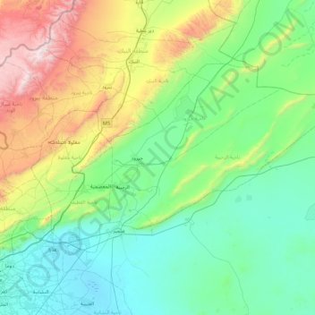
Name: Al-Qutayfah District topographic map, elevation, terrain.
Location: Al-Qutayfah District, Rif Dimashq Governorate, Syria (33.59879 36.45839 34.01796 37.30016)
Average elevation: 1,053 m
Minimum elevation: 595 m
Maximum elevation: 2,623 m
Other topographic maps
Click on a map to view its topography, its elevation and its terrain.
An-Nabk
Syria > Rif Dimashq Governorate
An-Nabek or Al-Nabek (Arabic: النبك, romanized: an-Nabk) is a Syrian city administratively belonging to Rif Dimashq and the capital of the Qalamoun. Located 81 kilometers (50 mi) north of Damascus and south of Homs. It has an altitude of 1255 meters. According to the Syria Central Bureau of Statistics…
Average elevation: 1,304 m
Hirista
Syria > Rif Dimashq Governorate
Harasta (Arabic: حرستا, romanized: Ḥarastā, Syriac: ܚܪܣܬܐ, romanized: Ḥarastā), also known as Harasta al-Basal or Hirista, is a town and northeastern suburb of Damascus, Rif Dimashq, Syria. Harasta has an altitude of 702 meters. It has a population of 34,184 as of 2007, making it the 43rd…
Average elevation: 728 m
Jabal Ash Shaykh
Syria > Rif Dimashq Governorate
Mount Hermon (Arabic: جبل الشيخ or جبل حرمون / ALA-LC: Jabal al-Shaykh ("Mountain of the Sheikh") or Jabal Haramun; Hebrew: הַר חֶרְמוֹן, Har Hermon) is a mountain cluster constituting the southern end of the Anti-Lebanon mountain range. Its summit straddles the border between Syria…
Average elevation: 2,516 m