Geolocate

Turk topographic map

Interactive map

Click on the map to display elevation.

About this map

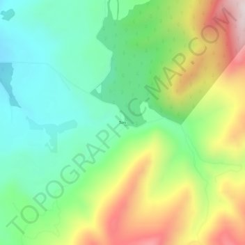
Name: Turk topographic map, elevation, terrain.

Location: Turk, Stevens County, Washington, United States (48.03405 -118.13331 48.07405 -118.09331)

Average elevation: 949 m

Minimum elevation: 681 m

Maximum elevation: 1,409 m

Other topographic maps

Click on a map to view its topography, its elevation and its terrain.

Addy

United States > Washington > Stevens County > Addy

Average elevation: 603 m

Loon Lake

United States > Washington > Stevens County

Average elevation: 779 m

Valley

United States > Washington > Stevens County > Valley

Average elevation: 555 m

Loon Lake

United States > Washington > Stevens County

Average elevation: 779 m

Northport

United States > Washington > Stevens County

Average elevation: 500 m

Colville

United States > Washington > Stevens County

Average elevation: 559 m

Springdale

United States > Washington > Stevens County

Average elevation: 656 m

Kettle Falls

United States > Washington > Stevens County

Average elevation: 508 m

Springdale

United States > Washington > Stevens County

Average elevation: 656 m

Colville

United States > Washington > Stevens County

Average elevation: 559 m

Chewelah

United States > Washington > Stevens County

Average elevation: 590 m

Kettle Falls

United States > Washington > Stevens County

Average elevation: 509 m