Geolocate

Richmond County topographic map

Interactive map

Click on the map to display elevation.

About this map

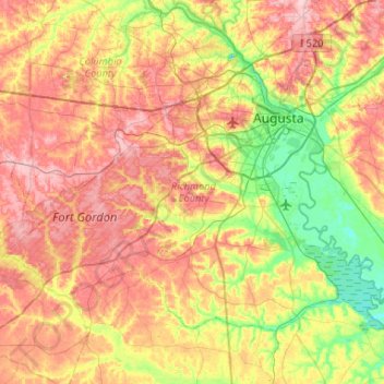
Name: Richmond County topographic map, elevation, terrain.

Location: Richmond County, Georgia, United States (33.22717 -82.35387 33.54502 -81.82812)

Average elevation: 96 m

Minimum elevation: 22 m

Maximum elevation: 177 m

Other topographic maps

Click on a map to view its topography, its elevation and its terrain.

DeBruce

United States > Georgia > Richmond County > Augusta

Average elevation: 75 m

Wheless

United States > Georgia > Richmond County > Augusta

Average elevation: 87 m

Colony Park

United States > Georgia > Richmond County > Augusta

Average elevation: 92 m

Dorchester

United States > Georgia > Richmond County > Augusta

Average elevation: 90 m

Salem

United States > Georgia > Richmond County > Augusta

Average elevation: 91 m

Terrace Manor

United States > Georgia > Richmond County > Augusta

Average elevation: 100 m

Dorchester

United States > Georgia > Richmond County > Augusta

Average elevation: 90 m

Forest Acres

United States > Georgia > Richmond County > Augusta

Average elevation: 67 m

Fairvale

United States > Georgia > Richmond County > Augusta

Average elevation: 56 m

Ellwood

United States > Georgia > Richmond County > Augusta

Average elevation: 119 m