
Make a donation
Gear up for your next adventure:
As an Amazon Associate, this site earns from qualifying purchases at no extra cost to you.
Zwinderen topographic map
Click on the map to display elevation.
Make a donation
Gear up for your next adventure:
As an Amazon Associate, this site earns from qualifying purchases at no extra cost to you.
Zwinderen
Bronnen vermelden: in Suinre (1217), de Swinre (1276), Swijnre (1295), Zwynderen (1527), Swinder (1811-13). De plaatsnaam is samengesteld uit : a) swin, zwin = waterloop, geul, kreek (afgeleid van swinan = verdwijnen, verzwinden) en horne (= hoek) of b) swin en heri, hara = met bos begroeide hoogte. De betekenis kan dan zijn: a) hoek aan de natuurlijke waterloop of b) zandige, begroeide hoogte aan de waterloop, in dit geval het Loodiep.
Make a donation
Gear up for your next adventure:
As an Amazon Associate, this site earns from qualifying purchases at no extra cost to you.
About this map
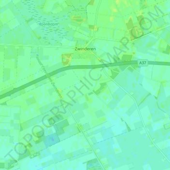
Name: Zwinderen topographic map, elevation, terrain.
Location: Zwinderen, Coevorden, Drenthe, Nederland (52.69696 6.63643 52.73813 6.71212)
Average elevation: 14 m
Minimum elevation: 9 m
Maximum elevation: 19 m
Make a donation
Gear up for your next adventure:
As an Amazon Associate, this site earns from qualifying purchases at no extra cost to you.
Other topographic maps
Click on a map to view its topography, its elevation and its terrain.
Make a donation
Gear up for your next adventure:
As an Amazon Associate, this site earns from qualifying purchases at no extra cost to you.