Geolocate

Franz Sigel Park topographic map

Interactive map

Click on the map to display elevation.

About this map

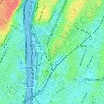
Name: Franz Sigel Park topographic map, elevation, terrain.

Location: Franz Sigel Park, Bronx County, The Bronx, New York, United States (40.82083 -73.92776 40.82574 -73.92375)

Average elevation: 16 m

Minimum elevation: -3 m

Maximum elevation: 56 m

Other topographic maps

Click on a map to view its topography, its elevation and its terrain.

Lenox Hill

United States > New York > New York

Average elevation: 20 m

Lookout Hill

United States > New York > New York

Average elevation: 32 m

Twin Island

United States > New York > New York

Average elevation: 41 m

Gravesend Bay

United States > New York > New York

Average elevation: 2 m

Kaiser Park

United States > New York > New York

Average elevation: 2 m

Emerson Hill

United States > New York > New York

Average elevation: 53 m

Sylvan Water

United States > New York > New York

Average elevation: 25 m

Flushing Meadows-Corona Park

United States > New York > New York

Around 1907, contractor Michael Degnon, whose firm constructed the Williamsburg Bridge, the Cape Cod Canal, and the Steinway subway tunnel (used by today's 7 and <7>​ trains), purchased large tracts of marsh near Flushing Creek. At the time, the land was considered "all but worthless". Degnon envisioned…

Average elevation: 15 m

Fort Greene Park

United States > New York > New York

Average elevation: 17 m

Lawrence Point

United States > New York > New York

Average elevation: 4 m

Flushing Bay

United States > New York > New York

Average elevation: 4 m

Willets Point

United States > New York > New York

Average elevation: 2 m

Todt Hill

United States > New York > New York

Average elevation: 75 m

Bowery Bay

United States > New York > New York

Average elevation: 5 m

Coastline access

United States > New York > New York

Average elevation: 3 m