
Daleiden topographic map
Interactive map
Click on the map to display elevation.
About this map
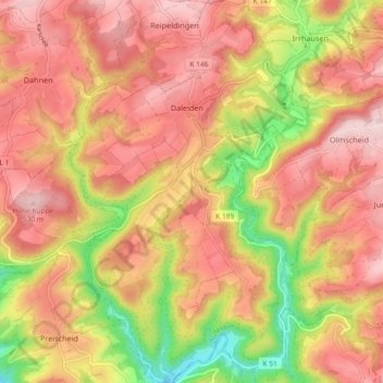
Name: Daleiden topographic map, elevation, terrain.
Average elevation: 431 m
Minimum elevation: 273 m
Maximum elevation: 531 m
Other topographic maps
Click on a map to view its topography, its elevation and its terrain.
Hüttingen an der Kyll
Deutschland > Rheinland-Pfalz > Eifelkreis Bitburg-Prüm
Hüttingen an der Kyll, Bitburger Land, Eifelkreis Bitburg-Prüm, Rheinland-Pfalz, Deutschland
Average elevation: 296 m
Wallendorf
Deutschland > Rheinland-Pfalz > Eifelkreis Bitburg-Prüm
Wallendorf, Südeifel, Eifelkreis Bitburg-Prüm, Rheinland-Pfalz, Deutschland
Average elevation: 296 m
Meckel
Deutschland > Rheinland-Pfalz > Eifelkreis Bitburg-Prüm
Meckel, Bitburger Land, Eifelkreis Bitburg-Prüm, Rheinland-Pfalz, Deutschland
Average elevation: 337 m
Ferschweiler
Deutschland > Rheinland-Pfalz > Eifelkreis Bitburg-Prüm
Ferschweiler, Südeifel, Eifelkreis Bitburg-Prüm, Rheinland-Pfalz, Deutschland
Average elevation: 346 m
Manderscheid
Deutschland > Rheinland-Pfalz > Eifelkreis Bitburg-Prüm
Manderscheid, Arzfeld, Eifelkreis Bitburg-Prüm, Rheinland-Pfalz, Deutschland
Average elevation: 433 m
Rodershausen
Deutschland > Rheinland-Pfalz > Eifelkreis Bitburg-Prüm > Rodershausen
Rodershausen, Südeifel, Eifelkreis Bitburg-Prüm, Rheinland-Pfalz, Deutschland
Average elevation: 443 m