
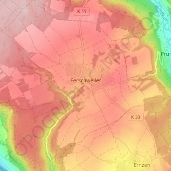
Ferschweiler topographic map
Interactive map
Click on the map to display elevation.
About this map
Name: Ferschweiler topographic map, elevation, terrain.
Average elevation: 346 m
Minimum elevation: 165 m
Maximum elevation: 428 m
Ferschweiler wird erstmals 751 in einer Urkunde der Abtei Echternach als Vilare erwähnt und lässt auf Reste römischer Besiedlung nach dem Untergang des Imperium Romanum schließen. Das Dorf wurde weltlich wie kirchlich von Echternach aus betreut. In Urkunden von 1069 und 1148 heißt der Ort Wilre, als Vertswiler wird 1161 eine „ecclesia“, 1410 eine Kapelle erwähnt. 1528 sind in Verswiler neun Feuerstellen (Häuser) verzeichnet. Von einer 1538 im spätgotischen Stil erbauten Kirche steht heute noch auf einer Höhe der Turm, nach der Hl. Lucia Luzienturm genannt.
Other topographic maps
Click on a map to view its topography, its elevation and its terrain.
Hüttingen an der Kyll
Deutschland > Rheinland-Pfalz > Eifelkreis Bitburg-Prüm
Hüttingen an der Kyll, Bitburger Land, Eifelkreis Bitburg-Prüm, Rheinland-Pfalz, Deutschland
Average elevation: 296 m
Wallendorf
Deutschland > Rheinland-Pfalz > Eifelkreis Bitburg-Prüm
Wallendorf, Südeifel, Eifelkreis Bitburg-Prüm, Rheinland-Pfalz, Deutschland
Average elevation: 296 m
Meckel
Deutschland > Rheinland-Pfalz > Eifelkreis Bitburg-Prüm
Meckel, Bitburger Land, Eifelkreis Bitburg-Prüm, Rheinland-Pfalz, Deutschland
Average elevation: 337 m
Daleiden
Deutschland > Rheinland-Pfalz > Eifelkreis Bitburg-Prüm
Daleiden, Arzfeld, Eifelkreis Bitburg-Prüm, Rheinland-Pfalz, 54689, Deutschland
Average elevation: 431 m
Manderscheid
Deutschland > Rheinland-Pfalz > Eifelkreis Bitburg-Prüm
Manderscheid, Arzfeld, Eifelkreis Bitburg-Prüm, Rheinland-Pfalz, Deutschland
Average elevation: 433 m
Rodershausen
Deutschland > Rheinland-Pfalz > Eifelkreis Bitburg-Prüm > Rodershausen
Rodershausen, Südeifel, Eifelkreis Bitburg-Prüm, Rheinland-Pfalz, Deutschland
Average elevation: 443 m