
Make a donation
Gear up for your next adventure:
As an Amazon Associate, this site earns from qualifying purchases at no extra cost to you.
Hancock topographic map
Click on the map to display elevation.
Make a donation
Gear up for your next adventure:
As an Amazon Associate, this site earns from qualifying purchases at no extra cost to you.
About this map
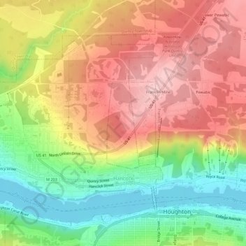
Name: Hancock topographic map, elevation, terrain.
Location: Hancock, Houghton County, Michigan, 49930, United States (47.12188 -88.62682 47.14853 -88.57220)
Average elevation: 276 m
Minimum elevation: 178 m
Maximum elevation: 364 m
Make a donation
Gear up for your next adventure:
As an Amazon Associate, this site earns from qualifying purchases at no extra cost to you.
Other topographic maps
Click on a map to view its topography, its elevation and its terrain.
Centennial Heights
United States > Michigan > Houghton County > Calumet Township
Average elevation: 364 m
Limestone Mountain
United States > Michigan > Houghton County > Laird Township
Average elevation: 245 m
Make a donation
Gear up for your next adventure:
As an Amazon Associate, this site earns from qualifying purchases at no extra cost to you.