
Deurali topographic map
Interactive map
Click on the map to display elevation.
About this map
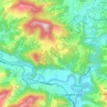
Name: Deurali topographic map, elevation, terrain.
Location: Deurali, Gorkha, Gandaki Pradesh, Nepal (27.90523 84.47452 27.96100 84.55903)
Average elevation: 574 m
Minimum elevation: 269 m
Maximum elevation: 1,250 m
Other topographic maps
Click on a map to view its topography, its elevation and its terrain.
Manakamana
Nepal > Gorkha > Manakamana
Manakamana, Sahid Lakhan, Gorkha, Gandaki Pradesh, Nepal
Average elevation: 1,014 m