Geolocate

Bryncae topographic map

Click on the map to display elevation.

About this map

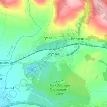
Name: Bryncae topographic map, elevation, terrain.

Location: Bryncae, Rhondda Cynon Taf, Wales, CF72 9WW, United Kingdom (51.51322 -3.47111 51.55322 -3.43111)

Average elevation: 101 m

Minimum elevation: 28 m

Maximum elevation: 258 m

Rhondda Cynon Taf trails, hiking, mountain biking, running and outdoor activities

Other topographic maps

Click on a map to view its topography, its elevation and its terrain.

Mid Glamorgan

United Kingdom > Wales > Rhondda Cynon Taf

Average elevation: 235 m

Pontypridd

United Kingdom > Wales > Rhondda Cynon Taf

Average elevation: 183 m

Penrhiwceiber

United Kingdom > Wales > Rhondda Cynon Taf

Average elevation: 229 m

Pontypridd

United Kingdom > Wales > Rhondda Cynon Taf

Average elevation: 183 m

Trealaw

United Kingdom > Wales > Rhondda Cynon Taf > Tonypandy

Average elevation: 222 m

Gear up for your next adventure:

👕Merino Base Layers - Natural temperature regulation for cold weather hiking and camping
🥼Base Layers - Thermal base layers for temperature regulation
🍲Portable Camping Stoves - Fast-boiling stoves for hot meals on remote topographic survey trips
🗺️Scratch-off Peak Maps - Track your progress climbing Munros or Wainwrights
🛰️Satellite Messengers - Emergency communication devices for areas without mobile signal

As an Amazon Associate, this site earns from qualifying purchases at no extra cost to you.