
Provincia Andrés Ibáñez topographic map
Interactive map
Click on the map to display elevation.
About this map
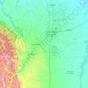
Name: Provincia Andrés Ibáñez topographic map, elevation, terrain.
Location: Provincia Andrés Ibáñez, Santa Cruz, Bolivia (-18.27145 -63.64676 -17.50810 -62.74864)
Average elevation: 535 m
Minimum elevation: 275 m
Maximum elevation: 1,886 m
Other topographic maps
Click on a map to view its topography, its elevation and its terrain.
Urubo
Bolivia > Santa Cruz > Provincia Andrés Ibáñez > Municipio Porongo (Ayacucho)
Average elevation: 415 m
Samaipata
Bolivia > Santa Cruz > Provincia Florida > Municipio Samaipata
Samaipata or Samaypata (Quechua samay to rest, pata elevated place / above, at the top / edge, bank (of a river), shore) is a small town in the Florida Province of the Santa Cruz Department in Bolivia. It has a subtropical climate and an altitude of 1600–1800 m. It lies about 120 kilometers to the southwest…
Average elevation: 1,695 m
Jorochito
Bolivia > Santa Cruz > Provincia Andrés Ibáñez > Municipio El Torno
Average elevation: 578 m
Atlantico Norte
Bolivia > Santa Cruz > Velasco > Municipio San Miguel de Velasco
Average elevation: 305 m
Laguna Esmeralda de Quirusillas
Bolivia > Santa Cruz > Provincia Florida > Municipio Quirusillas
Average elevation: 2,070 m
Junta Pirai
Bolivia > Santa Cruz > Provincia Andrés Ibáñez > Municipio El Torno
Average elevation: 538 m
Puerto Limon
Bolivia > Santa Cruz > Provincia Florida > Municipio Samaipata
Average elevation: 1,457 m
Samaipata
Bolivia > Santa Cruz > Provincia Florida > Municipio Samaipata
Samaipata or Samaypata (Quechua samay to rest, pata elevated place / above, at the top / edge, bank (of a river), shore) is a small town in the Florida Province of the Santa Cruz Department in Bolivia. It has a subtropical climate and an altitude of 1600–1800 m. It lies about 120 kilometers to the southwest…
Average elevation: 1,695 m
Provincia Manuel María Caballero
Bolivia > Santa Cruz > Provincia Manuel M. Caballero > Municipio Comarapa
Average elevation: 2,306 m
Estancia San Sabastian
Bolivia > Santa Cruz > Provincia Ángel Sandóval > Municipio San Matías > Estancia San Sabastian
Average elevation: 126 m
Punilla
Bolivia > Santa Cruz > Provincia Manuel M. Caballero > Municipio Comarapa
Average elevation: 2,376 m
General Saavedra
Bolivia > Santa Cruz > Provincia Obispo Santistevan > Municipio General Saavedra > General Saavedra
Average elevation: 269 m
Los Andes
Bolivia > Santa Cruz > Provincia Ichilo > Municipio San Juan > Los Andes
Average elevation: 248 m
San Pedro
Bolivia > Santa Cruz > Provincia Ñuflo de Chávez > Municipio Concepción > San Pedro
Average elevation: 570 m