
Make a donation
Gear up for your next adventure:
As an Amazon Associate, this site earns from qualifying purchases at no extra cost to you.
Hyndman Peak topographic map
Click on the map to display elevation.
Make a donation
Gear up for your next adventure:
As an Amazon Associate, this site earns from qualifying purchases at no extra cost to you.
Hyndman Peak
Hyndman Peak, at an elevation of 12,012 feet (3,661 m) above sea level, is the ninth highest peak in Idaho and the highest point in the Pioneer Mountains, Sawtooth National Forest, and Blaine County. Hyndman Peak is located on the border of Custer and Blaine counties. The towns of Hailey, Ketchum, and Sun Valley are west of the peak.
Make a donation
Gear up for your next adventure:
As an Amazon Associate, this site earns from qualifying purchases at no extra cost to you.
About this map
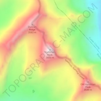
Name: Hyndman Peak topographic map, elevation, terrain.
Location: Hyndman Peak, Blaine County, Idaho, United States (43.74932 -114.13113 43.74942 -114.13103)
Average elevation: 3,170 m
Minimum elevation: 2,708 m
Maximum elevation: 3,645 m
Make a donation
Gear up for your next adventure:
As an Amazon Associate, this site earns from qualifying purchases at no extra cost to you.
Other topographic maps
Click on a map to view its topography, its elevation and its terrain.
Sun Valley
United States > Idaho > Blaine County
Sun Valley is a resort city in the western United States, in Blaine County, Idaho, adjacent to the city of Ketchum in the Wood River valley. The population was 1406 at the 2010 census, down from 1427 in 2000. The elevation of Sun Valley (at the Lodge) is 5,920 feet (1,805 m) above sea level.
Average elevation: 1,988 m
Ketchum
United States > Idaho > Blaine County
After the mining boom subsided in the 1890s, sheepmen from the south drove their flocks north through Ketchum in the summer, to graze in the upper elevation areas of the Pioneer, Boulder, and Sawtooth mountains. By 1920, Ketchum had become the largest sheep-shipping center in the West. In the fall, massive…
Average elevation: 1,906 m
Alice Lake
United States > Idaho > Blaine County
The direct route to the lake begins at the trailhead at the end of the Pettit Lake campground. The trail distance is about 5.5 mi (9 km) to the lake and gains about 1,600 feet (490 m) in elevation. The trail requires five stream crossings, only the last of which has a bridge.
Average elevation: 2,747 m
Make a donation
Gear up for your next adventure:
As an Amazon Associate, this site earns from qualifying purchases at no extra cost to you.
Sun Valley
United States > Idaho > Blaine County
Sun Valley is a resort city in the western United States, in Blaine County, Idaho, adjacent to the city of Ketchum in the Wood River valley. The population was 1,783 at the 2020 census. The elevation of Sun Valley (at the Lodge) is 5,920 feet (1,805 m) above sea level.
Average elevation: 1,988 m
Make a donation
Gear up for your next adventure:
As an Amazon Associate, this site earns from qualifying purchases at no extra cost to you.
Sun Valley
United States > Idaho > Blaine County
Sun Valley is a resort city in the western United States, in Blaine County, Idaho, adjacent to the city of Ketchum in the Wood River valley. The population was 1,783 at the 2020 census. The elevation of Sun Valley (at the Lodge) is 5,920 feet (1,805 m) above sea level.
Average elevation: 1,988 m
Hailey
United States > Idaho > Blaine County
Hailey is located at 43°30′54″N 114°18′23″W / 43.51500°N 114.30639°W / 43.51500; -114.30639 (43.514937, -114.306251), at an elevation of 5,318 feet (1,621 m) above sea level.
Average elevation: 1,729 m
Ketchum
United States > Idaho > Blaine County
After the mining boom subsided in the 1890s, sheepmen from the south drove their flocks north through Ketchum in the summer, to graze in the upper elevation areas of the Pioneer, Boulder, and Sawtooth mountains. By 1920, Ketchum had become the largest sheep-shipping center in the West. In the fall, massive…
Average elevation: 1,906 m