

Ketchum topographic map
Click on the map to display elevation.
Ketchum
After the mining boom subsided in the 1890s, sheepmen from the south drove their flocks north through Ketchum in the summer, to graze in the upper elevation areas of the Pioneer, Boulder, and Sawtooth mountains. By 1920, Ketchum had become the largest sheep-shipping center in the West. In the fall, massive flocks of sheep flowed south into the town's livestock corrals at the Union Pacific Railroad's railhead, which connected to the main line at Shoshone.
About this map
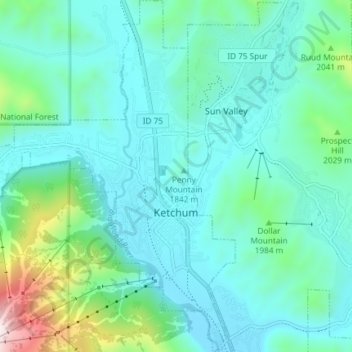
Name: Ketchum topographic map, elevation, terrain.
Location: Ketchum, Blaine County, Idaho, United States (43.65955 -114.41189 43.71297 -114.35118)
Average elevation: 1,906 m
Minimum elevation: 1,742 m
Maximum elevation: 2,671 m
Other topographic maps
Click on a map to view its topography, its elevation and its terrain.



Hyndman Peak
United States > Idaho > Blaine County
Hyndman Peak, at an elevation of 12,012 feet (3,661 m) above sea level, is the ninth highest peak in Idaho and the highest point in the Pioneer Mountains, Sawtooth National Forest, and Blaine County. Hyndman Peak is located on the border of Custer and Blaine counties. The towns of Hailey, Ketchum, and Sun…
Average elevation: 3,170 m