Geolocate

Pagbilao topographic map

Click on the map to display elevation.

About this map

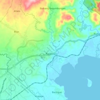
Name: Pagbilao topographic map, elevation, terrain.

Location: Pagbilao, Quezon, Calabarzon, 4302, Philippines (13.93460 121.64545 14.01460 121.72545)

Average elevation: 45 m

Minimum elevation: -1 m

Maximum elevation: 207 m

Other topographic maps

Click on a map to view its topography, its elevation and its terrain.

Ibabang Palsabangon

Philippines > Quezon > Pagbilao

Average elevation: 117 m

Pagbilao Grande Island

Philippines > Quezon > Pagbilao

Average elevation: 13 m

Ibabang Polo

Philippines > Quezon > Pagbilao

Average elevation: 9 m

Talipan

Philippines > Quezon > Pagbilao

Average elevation: 56 m

Binahaan

Philippines > Quezon > Pagbilao

Average elevation: 122 m

Ilayang Palsabangon

Philippines > Quezon > Pagbilao

Average elevation: 136 m

Binahaan

Philippines > Quezon > Pagbilao

Average elevation: 122 m

Gear up for your next adventure:

🚲Bikepacking Frame Bags - Storage for tools and navigation gear on long off-road rides
🧣Fleece Neck Warmers - Extra insulation for winter topographic surveys
🧷Tenacious Repair Tape - Instant fix for torn tents, jackets, or dry bags
🧤Thermal Touchscreen Gloves - Stay warm while operating your GPS or smartphone camera
🥄Titanium Camping Sporks - The ultimate lightweight utensil for trail meals

As an Amazon Associate, this site earns from qualifying purchases at no extra cost to you.