
Make a donation
Gear up for your next adventure:
As an Amazon Associate, this site earns from qualifying purchases at no extra cost to you.
Goris topographic map
Click on the map to display elevation.
Make a donation
Gear up for your next adventure:
As an Amazon Associate, this site earns from qualifying purchases at no extra cost to you.
Goris
Goris is situated in the valley of Goris River, also known as Vararak River. The valley is surrounded with the Zangezur Mountains. The town has an average elevation of 1,385 metres above sea level. The surrounding mountains are famous for their medieval cave-dwellings carved out of the soft rock in the southern and eastern parts of the town. The Goris Wildlife Sanctuary is situated at the southeast of the town at a height ranging between 1400 and 2800 meters above sea level, covering an area of 18.5 km². Caucasian grouse, roe deer and brown bear are among the notable animals in the sanctuary.
Make a donation
Gear up for your next adventure:
As an Amazon Associate, this site earns from qualifying purchases at no extra cost to you.
About this map
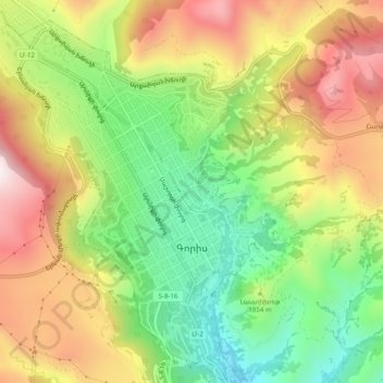
Name: Goris topographic map, elevation, terrain.
Location: Goris, Goris community, Syunik Province, Armenia (39.49195 46.31325 39.52979 46.35320)
Average elevation: 1,513 m
Minimum elevation: 1,210 m
Maximum elevation: 1,865 m
Make a donation
Gear up for your next adventure:
As an Amazon Associate, this site earns from qualifying purchases at no extra cost to you.
Other topographic maps
Click on a map to view its topography, its elevation and its terrain.
Kapan
The town is about 80 km (50 mi) north of the Iranian border. With a height of 3201 meters, Mount Khustup is the highest peak of the region. The elevation of Kapan is 750–1050 meters above sea level, with an average height of 910 meters. Two tributaries of the Voghji River, Vachagan and Kavart, flow through…
Average elevation: 1,110 m
Halidzor
Geographically, Halidzor is located near the left bank of the Vorotan River, at an altitude of 1300-1350 m above sea level. The regional center of Syunik province - the city of Kapan, is 62 km away. The nearest town is Goris, which is 12 km to the southwest.
Average elevation: 1,326 m
Make a donation
Gear up for your next adventure:
As an Amazon Associate, this site earns from qualifying purchases at no extra cost to you.
Make a donation
Gear up for your next adventure:
As an Amazon Associate, this site earns from qualifying purchases at no extra cost to you.