
Kreuth topographic map
Interactive map
Click on the map to display elevation.
About this map
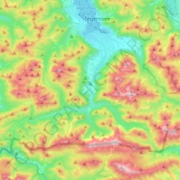
Name: Kreuth topographic map, elevation, terrain.
Location: Kreuth, Landkreis Miesbach, Bavaria, 83708, Germany (47.58121 11.59798 47.70095 11.85496)
Average elevation: 1,137 m
Minimum elevation: 722 m
Maximum elevation: 1,823 m
Other topographic maps
Click on a map to view its topography, its elevation and its terrain.
Buch
Germany > Bavaria > Landkreis Miesbach > Bad Wiessee
Buch, Bad Wiessee, Landkreis Miesbach, Bavaria, 83707, Germany
Average elevation: 904 m
Miesbach
Germany > Bavaria > Landkreis Miesbach
Miesbach, Landkreis Miesbach, Bavaria, 83714, Germany
Average elevation: 739 m
Schliersee
Germany > Bavaria > Landkreis Miesbach
Schliersee, Landkreis Miesbach, Bavaria, 83727, Germany
Average elevation: 1,079 m
Floiger
Germany > Bavaria > Landkreis Miesbach > Miesbach
Floiger, Miesbach, Landkreis Miesbach, Bavaria, 83714, Germany
Average elevation: 769 m
Kalten
Germany > Bavaria > Landkreis Miesbach > Niklasreuth
Kalten, Niklasreuth, Irschenberg, Landkreis Miesbach, Bavaria, 83737, Germany
Average elevation: 682 m
Rottach-Egern
Germany > Bavaria > Landkreis Miesbach
Rottach-Egern, Landkreis Miesbach, Bavaria, 83700, Germany
Average elevation: 1,086 m
Tegernsee
Germany > Bavaria > Landkreis Miesbach
Tegernsee, Landkreis Miesbach, Bavaria, 83684, Germany
Average elevation: 858 m
Hausham
Germany > Bavaria > Landkreis Miesbach > Hausham
Hausham, Landkreis Miesbach, Bavaria, 83734, Germany
Average elevation: 854 m