Geolocate

Holywell topographic map

Click on the map to display elevation.

About this map

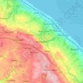
Name: Holywell topographic map, elevation, terrain.

Location: Holywell, Flintshire, Wales, CH8 7UR, United Kingdom (53.23141 -3.26130 53.31141 -3.18130)

Average elevation: 119 m

Minimum elevation: 0 m

Maximum elevation: 292 m

Flintshire trails, hiking, mountain biking, running and outdoor activities

Other topographic maps

Click on a map to view its topography, its elevation and its terrain.

Penyffordd

United Kingdom > Wales > Flintshire

Average elevation: 101 m

Ewloe Castle

United Kingdom > Wales > Flintshire > Ewloe

Average elevation: 74 m

Bagilt Reservior

United Kingdom > Wales > Flintshire > Bagillt

Average elevation: 32 m

Wepre Park

United Kingdom > Wales > Flintshire > Connah's Quay

Average elevation: 46 m

Saltney

United Kingdom > Wales > Flintshire

Average elevation: 9 m

Point of Ayr

United Kingdom > Wales > Flintshire > Talacre

Average elevation: 2 m

Nannerch

United Kingdom > Wales > Flintshire > Nannerch

Average elevation: 232 m

Gear up for your next adventure:

🔋Power Banks - Portable chargers for long outdoor trips
🥾Women's Waterproof Hiking Boots - High-performance trekking boots designed for all-weather comfort
🧭Emergency Beacons - Safety beacons for remote outdoor locations
📷Outdoor Action Cameras - Cameras designed for hiking and adventure
🩹Hiking First Aid Kits - Compact medical kits tailored for trail injuries and emergencies

As an Amazon Associate, this site earns from qualifying purchases at no extra cost to you.