
Sub Cetate topographic map
Click on the map to display elevation.
About this map
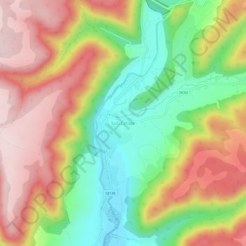
Name: Sub Cetate topographic map, elevation, terrain.
Location: Sub Cetate, Zetea, Harghita, 537366, Romania (46.42427 25.37219 46.46427 25.41219)
Average elevation: 714 m
Minimum elevation: 557 m
Maximum elevation: 870 m
Other topographic maps
Click on a map to view its topography, its elevation and its terrain.
Băile Tușnad
With a population of 1,372 (as of 2021), it is the smallest town in Romania by population. It is located at an altitude of 650 m (2,130 ft) in the southern reaches of the Ciuc depression, between the Harghita and Bodoc mountains, in the valley of the Olt River, and is to this day an important spa town. The…
Average elevation: 882 m
Borsec
Borsec, a resort chiefly known for its mineral water and favourable climate, is situated in the intracarpatic depression of the same name, at an altitude of 900 m (3,000 ft). The Borsec Depression has an oval shape and is northeast oriented, being separated from the hilltop of the Rotunda Chair in two…
Average elevation: 1,053 m
Băile Tușnad
With a population of 1,372 (as of 2021), it is the smallest town in Romania by population. It is located at an altitude of 650 m (2,130 ft) in the southern reaches of the Ciuc depression, between the Harghita and Bodoc mountains, in the valley of the Olt River, and is to this day an important spa town. The…
Average elevation: 882 m
Băile Tușnad
With a population of 1,617, it is the smallest town in Romania by population. It is located at an altitude of 650 metres in the southern reaches of the Ciuc depression, between the Harghita and Bodoc mountains, in the valley of the Olt, and is to this day an important spa town. The town administers one…
Average elevation: 833 m