
Make a donation
Gear up for your next adventure:
As an Amazon Associate, this site earns from qualifying purchases at no extra cost to you.
Borsec topographic map
Click on the map to display elevation.
Make a donation
Gear up for your next adventure:
As an Amazon Associate, this site earns from qualifying purchases at no extra cost to you.
Borsec
Borsec, a resort chiefly known for its mineral water and favourable climate, is situated in the intracarpatic depression of the same name, at an altitude of 900 m (3,000 ft). The Borsec Depression has an oval shape and is northeast oriented, being separated from the hilltop of the Rotunda Chair in two subunits. The locality is composed of two areas that correspond geographically to the two small depression areas that join: The Upper Borsec (Borsec de Sus) and The Lower Borsec (Borsec de Jos). The latter is southwest along national road DN15 [ro] at its junction with county road DJ128 Borsec-Ditrău, and Borsec de Sus (or the resort itself) is located on the plateau located northeast of the primary settlement, which is at higher altitude on average with 80–100 m. In the west, at a short distance, one can reach Toplița, the Pass of Creangă and to the east the Bistricioara valley. The Borsec depression is located at a higher altitude to that of Giurgeu but lower than that of Bilbor. Within the resort there are alleys and tourist trails, most of which are located in the outskirts of the resort, especially for visiting the nature monuments from the reservation of the Scaunul Rotund and Făget (Bükkhavas). They have the necessary arrangements to perform the field treatment under appropriate conditions, including tourist markings.
Make a donation
Gear up for your next adventure:
As an Amazon Associate, this site earns from qualifying purchases at no extra cost to you.
About this map
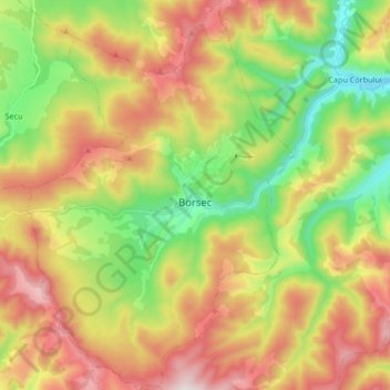
Name: Borsec topographic map, elevation, terrain.
Location: Borsec, Harghita, 535300, Romania (46.90908 25.48896 47.02268 25.60373)
Average elevation: 1,053 m
Minimum elevation: 712 m
Maximum elevation: 1,464 m
Make a donation
Gear up for your next adventure:
As an Amazon Associate, this site earns from qualifying purchases at no extra cost to you.
Other topographic maps
Click on a map to view its topography, its elevation and its terrain.
Carpathian Mountains
The northwestern Carpathians begin in Slovakia and southern Poland. They surround Transcarpathia and Transylvania in a large semicircle, sweeping towards the southeast, and end on the Danube near Orșova in Romania. The total length of the Carpathians is over 1,500 km (930 mi). The mountain chain's width…
Average elevation: 980 m
Make a donation
Gear up for your next adventure:
As an Amazon Associate, this site earns from qualifying purchases at no extra cost to you.
Make a donation
Gear up for your next adventure:
As an Amazon Associate, this site earns from qualifying purchases at no extra cost to you.
Make a donation
Gear up for your next adventure:
As an Amazon Associate, this site earns from qualifying purchases at no extra cost to you.
Make a donation
Gear up for your next adventure:
As an Amazon Associate, this site earns from qualifying purchases at no extra cost to you.
Make a donation
Gear up for your next adventure:
As an Amazon Associate, this site earns from qualifying purchases at no extra cost to you.
Make a donation
Gear up for your next adventure:
As an Amazon Associate, this site earns from qualifying purchases at no extra cost to you.
Băile Tușnad
With a population of 1,617, it is the smallest town in Romania by population. It is located at an altitude of 650 metres in the southern reaches of the Ciuc depression, between the Harghita and Bodoc mountains, in the valley of the Olt, and is to this day an important spa town. The town administers one…
Average elevation: 833 m
Make a donation
Gear up for your next adventure:
As an Amazon Associate, this site earns from qualifying purchases at no extra cost to you.