Geolocate

Lingig topographic map

Click on the map to display elevation.

About this map

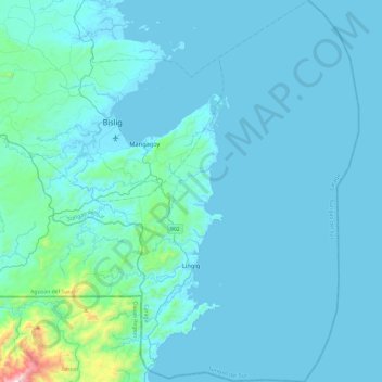
Name: Lingig topographic map, elevation, terrain.

Location: Lingig, Surigao del Sur, Caraga, 8312, Philippines (7.89663 126.21250 8.36162 126.61893)

Average elevation: 69 m

Minimum elevation: 0 m

Maximum elevation: 1,126 m

Other topographic maps

Click on a map to view its topography, its elevation and its terrain.

Carrascal

Philippines > Surigao del Sur

Average elevation: 24 m

Gear up for your next adventure:

🥤Collapsible Water Bottles - Save space in your rucksack as you consume your water
Lightweight Tents - Compact tents for backpacking and trekking
📍Handheld GPS Navigators - Reliable satellite navigation for hiking and off-road exploration
🕶️Polarized Sunglasses - Reduces glare from snow and water when reading terrain
🧢Thermal Beanie Hats - Prevent heat loss from the head in windy summit conditions

As an Amazon Associate, this site earns from qualifying purchases at no extra cost to you.