Geolocate

Lianga topographic map

Click on the map to display elevation.

About this map

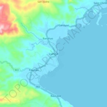
Name: Lianga topographic map, elevation, terrain.

Location: Lianga, Surigao del Sur, Caraga, 8307, Philippines (8.59302 126.05348 8.67302 126.13348)

Average elevation: 65 m

Minimum elevation: 0 m

Maximum elevation: 474 m

Other topographic maps

Click on a map to view its topography, its elevation and its terrain.

Bislig

Philippines > Surigao del Sur

Average elevation: 71 m

Lingig

Philippines > Surigao del Sur

Average elevation: 70 m

Bayabas

Philippines > Surigao del Sur

Average elevation: 35 m

Hinatuan

Philippines > Surigao del Sur

Average elevation: 30 m

Lingig

Philippines > Surigao del Sur

Average elevation: 70 m

Carac-an River

Philippines > Surigao del Sur > Cancavan

Average elevation: 23 m

Bislig

Philippines > Surigao del Sur

Average elevation: 71 m

Hinatuan

Philippines > Surigao del Sur

Average elevation: 30 m

Hinatuan

Philippines > Surigao del Sur

Average elevation: 30 m

Gear up for your next adventure:

📷Camera Straps - Secure straps for carrying cameras while walking
🍲Portable Camping Stoves - Fast-boiling stoves for hot meals on remote topographic survey trips
🧵Survival Paracord - Multi-purpose cordage for emergency repairs and shelters
🥾Hiking Boot Waterproofing Wax - Maintain the lifespan of your leather trekking boots
🧴Sport Sunscreen Sticks - High-protection sunblock that won't run into your eyes on the trail

As an Amazon Associate, this site earns from qualifying purchases at no extra cost to you.