
Gyrn Goch topographic map
Click on the map to display elevation.
About this map
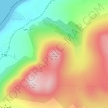
Name: Gyrn Goch topographic map, elevation, terrain.
Location: Gyrn Goch, Gwynedd, Wales, LL54 5NW, United Kingdom (53.00158 -4.37456 53.00168 -4.37446)
Average elevation: 251 m
Minimum elevation: 0 m
Maximum elevation: 511 m
Gwynedd trails, hiking, mountain biking, running and outdoor activities
Other topographic maps
Click on a map to view its topography, its elevation and its terrain.
Morfa Harlech National Nature Reserve
United Kingdom > Wales > Gwynedd > Harlech
Average elevation: 3 m
Parc Tan-y-Bwlch
United Kingdom > Wales > Gwynedd > Mynydd Llandygái > Pen Y Bwlch
Average elevation: 293 m
Carneddau
United Kingdom > Wales > Gwynedd > Abergwyngregyn
The plants growing on the Carneddau need to be extremely hardy to withstand the snow, frosts, and gales they will encounter during the year and those found by sheltered streams in the valleys are very different from those clinging to crevices on windswept rocks. Sheep graze the mountains and impact the…
Average elevation: 408 m