
Xinyi Township topographic map
Interactive map
Click on the map to display elevation.
About this map
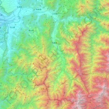
Name: Xinyi Township topographic map, elevation, terrain.
Location: Xinyi Township, Nantou County, Taiwan (23.43520 120.80394 23.86479 121.24130)
Average elevation: 1,329 m
Minimum elevation: 82 m
Maximum elevation: 3,882 m
Other topographic maps
Click on a map to view its topography, its elevation and its terrain.
Yushan
Taiwan > Nantou County > Xinyi Township
Yu Shan or Yushan, also known as Mount Jade, Jade Mountain, or Mount Yu, and known as Mount Niitaka during Japanese rule, is the highest mountain in Taiwan at 3,952 m (12,966 ft) above sea level, giving Taiwan the 4th-highest maximum elevation of any island in the world. It is the highest point in the western…
Average elevation: 3,411 m