
Ramacca topographic map
Interactive map
Click on the map to display elevation.
About this map
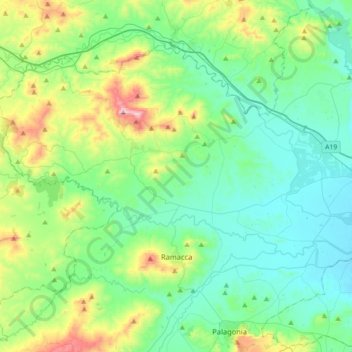
Name: Ramacca topographic map, elevation, terrain.
Location: Ramacca, Catania, Sicily, 95040, Italy (37.35581 14.53252 37.54914 14.88819)
Average elevation: 192 m
Minimum elevation: 29 m
Maximum elevation: 749 m
Other topographic maps
Click on a map to view its topography, its elevation and its terrain.
Riserva naturale orientata Sughereta di Niscemi
Italy > Sicily > Catania > Caltagirone
Average elevation: 176 m
Catania
Around 263 BC, the city was variously known as Catĭna (Latin: [ˈkatɪna]) and Catăna (Latin: [ˈkatana]; Ancient Greek: Κατάνη [katánɛː]). The former has been primarily used for its supposed assonance with catina, the Latin feminization of the name catinus. Catinus has two meanings: "a gulf, a…
Average elevation: 50 m
Maletto
The geographical location of Maletto also influences its climate. The town experiences a Mediterranean climate, characterized by hot, dry summers and mild, rainy winters. However, due to its proximity to Mount Etna, microclimates can be observed, with variations in temperature and precipitation depending on…
Average elevation: 983 m
Etna
Italy > Sicily > Catania > Zafferana Etnea
Eruptions of Etna follow multiple patterns. Most occur at the summit, where there are five distinct craters – the Northeast Crater, the Voragine, the Bocca Nuova, and two at the Southeast Crater Complex. Other eruptions occur on the flanks, which have more than 300 vents ranging in size from small holes in…
Average elevation: 2,976 m
Mount Etna
During the first 1500 years CE, many eruptions went unrecorded (or records have been lost); among the more significant are: (1) an eruption in about 1030 CE near Monte Ilice on the lower southeast flank, which produced a lava flow that travelled about 10 km, reaching the sea north of Acireale; the villages of…
Average elevation: 1,157 m