Geolocate

Numão topographic map

Click on the map to display elevation.

About this map
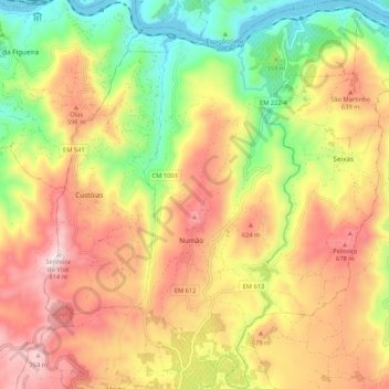
Name: Numão topographic map, elevation, terrain.

Location: Numão, Vila Nova de Foz Côa, Guarda, 5155-638, Portugal (41.06558 -7.30909 41.14500 -7.24421)

Average elevation: 453 m

Minimum elevation: 103 m

Maximum elevation: 802 m

Other topographic maps

Click on a map to view its topography, its elevation and its terrain.

Cortes da Veiga

Portugal > Guarda > Vila Nova de Foz Coa

Average elevation: 217 m

Arnozelo

Portugal > Guarda > Vila Nova de Foz Coa > Numão

Average elevation: 283 m

Touça

Portugal > Guarda > Vila Nova de Foz Coa > Touça

Average elevation: 610 m

Cedovim

Portugal > Guarda > Vila Nova de Foz Coa

Average elevation: 613 m

Senhora do Viso

Portugal > Guarda > Vila Nova de Foz Coa

Average elevation: 601 m

Orgal

Portugal > Guarda > Vila Nova de Foz Coa > Castelo Melhor

Average elevation: 312 m

Gear up for your next adventure:

🩹Hiking First Aid Kits - Compact medical kits tailored for trail injuries and emergencies
🥤Hiking Water Bottles - Reusable bottles for hydration on the trail
🔋Lithium AA Batteries - Long-lasting power that performs well in cold mountain weather
🧥Softshell Jackets - Breathable jackets for active outdoor use
🎒Backpack Rain Covers - Universal waterproof covers to protect your gear from downpours

As an Amazon Associate, this site earns from qualifying purchases at no extra cost to you.