
Lake Louise topographic map
Interactive map
Click on the map to display elevation.
About this map
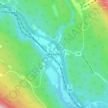
Name: Lake Louise topographic map, elevation, terrain.
Location: Lake Louise, Division No. 15, Alberta, Canada (51.40497 -116.19754 51.44497 -116.15754)
Average elevation: 1,617 m
Minimum elevation: 1,518 m
Maximum elevation: 1,934 m
Lake Louise is a hamlet within Banff National Park in Alberta, Canada. Named after Princess Louise, Duchess of Argyll, it lies in Alberta's Rockies on the Bow River, 3 km (1.9 mi) northeast of the lake that shares its name. Initially settled in 1884 as an outpost for the Canadian Pacific Railway, Lake Louise sits at an elevation of 1,600 m (5,200 ft), making it Canada's highest community. The nearby lake, framed by mountains, is one of the most famous mountain vistas in the world; the famous Chateau Lake Louise also overlooks the lake.[4]
Other topographic maps
Click on a map to view its topography, its elevation and its terrain.
Banff National Park
Canada > Alberta > Division No. 15
Banff National Park, Division No. 15, Alberta, Canada
Average elevation: 1,848 m
Moraine Lake
Canada > Alberta > Division No. 15
Moraine Lake, Division No. 15, Alberta, Canada
Average elevation: 2,101 m
Jasper National Park
Canada > Alberta > Division No. 15
Jasper National Park, Division No. 15, Alberta, Canada
Average elevation: 1,782 m
Toronto Peak
Canada > Alberta > Division No. 15
Toronto Peak, Division No. 15, Alberta, Canada
Average elevation: 2,423 m