Geolocate

Calcoed topographic map

Interactive map

Click on the map to display elevation.

About this map

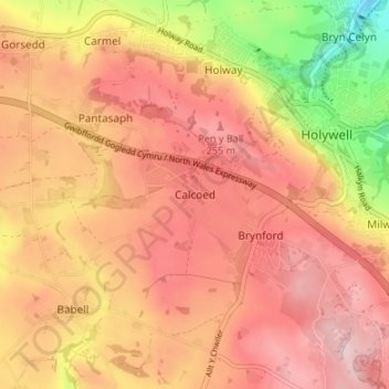
Name: Calcoed topographic map, elevation, terrain.

Location: Calcoed, Flintshire, Wales, CH8 8LF, United Kingdom (53.24522 -3.26395 53.28522 -3.22395)

Average elevation: 195 m

Minimum elevation: 37 m

Maximum elevation: 284 m

Flintshire trails, hiking, mountain biking, running and outdoor activities

Other topographic maps

Click on a map to view its topography, its elevation and its terrain.

Saltney

United Kingdom > Wales > Flintshire

Average elevation: 9 m

Wepre Park

United Kingdom > Wales > Flintshire > Connah's Quay

Average elevation: 46 m

Penyffordd

United Kingdom > Wales > Flintshire

Average elevation: 101 m

Bagilt Reservior

United Kingdom > Wales > Flintshire > Bagillt

Average elevation: 32 m

Nannerch

United Kingdom > Wales > Flintshire > Nannerch

Average elevation: 232 m

Ewloe Castle

United Kingdom > Wales > Flintshire > Ewloe

Average elevation: 74 m