Geolocate

Palouse topographic map

Click on the map to display elevation.

About this map

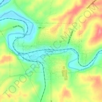
Name: Palouse topographic map, elevation, terrain.

Location: Palouse, Whitman County, Washington, 99161, United States (46.90246 -117.09072 46.91778 -117.06091)

Average elevation: 774 m

Minimum elevation: 734 m

Maximum elevation: 825 m

Other topographic maps

Click on a map to view its topography, its elevation and its terrain.

Almota

United States > Washington > Whitman County

Average elevation: 339 m

Armstrong

United States > Washington > Whitman County > Pullman

Average elevation: 747 m

Madson

United States > Washington > Whitman County

Average elevation: 793 m

Pullman

United States > Washington > Whitman County > Pullman > Pullman

The city is situated across several loess hills which characterize the Palouse Prairie, formed from windblown sediment over an estimated period of over one million years. This prairie region, the Palouse, is noteworthy for its fertile rolling hills where winter and spring wheat, barley, lentils, and peas are…

Average elevation: 774 m

Kamiak Butte

United States > Washington > Whitman County

Average elevation: 883 m

LaCrosse

United States > Washington > Whitman County > La Crosse

Average elevation: 471 m

Chamber

United States > Washington > Whitman County

Average elevation: 812 m

Thornton

United States > Washington > Whitman County > Thornton

Average elevation: 733 m

Gear up for your next adventure:

🧺Ultralight Dry Bags - Organize and waterproof your gear inside your rucksack
🗺️Scratch-off Peak Maps - Track your progress climbing Munros or Wainwrights
🕶️Glacier Goggles - Maximum protection for high-altitude snow topography
🎒Hiking Daypacks (20L) - Compact backpacks for day trips and technical mountain ascents
👟Waterproof Leg Gaiters - Keep mud and water out of your boots in boggy terrain

As an Amazon Associate, this site earns from qualifying purchases at no extra cost to you.