
Coahuayana topographic map
Interactive map
Click on the map to display elevation.
About this map
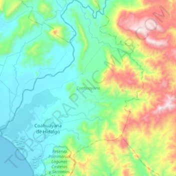
Name: Coahuayana topographic map, elevation, terrain.
Location: Coahuayana, Michoacán, Mexico (18.62368 -103.73905 18.89324 -103.50704)
Average elevation: 391 m
Minimum elevation: 0 m
Maximum elevation: 1,558 m
Other topographic maps
Click on a map to view its topography, its elevation and its terrain.
Zamora
The city of Zamora is an important economic center in the state and the most significant population center between the cities of Morelia and Guadalajara. The city is located on the Tarascan Plateau in the northwestern part of the state, at an elevation of 1,567 m (5,141 ft) above sea level. Zamora is…
Average elevation: 1,798 m
Ihuatzio
Mexico > Michoacán > Tzintzuntzan
Ihuatzio is located on the southeast of the Lake Pátzcuaro, about 8 kilometers southwest of the town center of Tzintzuntzan. Its average elevation is 2,052 meters above the sea level.
Average elevation: 2,052 m