Geolocate

Boston topographic map

Click on the map to display elevation.

About this map

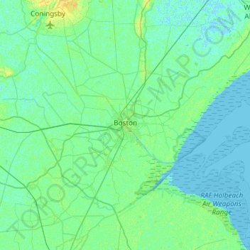
Name: Boston topographic map, elevation, terrain.

Location: Boston, Lincolnshire, Greater Lincolnshire, England, United Kingdom (52.86280 -0.24671 53.08666 0.23855)

Average elevation: 3 m

Minimum elevation: -2 m

Maximum elevation: 14 m

Lincolnshire trails, hiking, mountain biking, running and outdoor activities

Other topographic maps

Click on a map to view its topography, its elevation and its terrain.

Ewerby

United Kingdom > England > Lincolnshire > North Kesteven

Average elevation: 11 m

Sudbrooke

United Kingdom > England > Lincolnshire > West Lindsey

Average elevation: 17 m

Steep Hill

United Kingdom > England > Lincolnshire > Lincoln

Average elevation: 32 m

Frampton

United Kingdom > England > Lincolnshire > Boston

Average elevation: 4 m

Holland Fen

United Kingdom > England > Lincolnshire > Boston

Average elevation: 3 m

Lincoln Castle

United Kingdom > England > Lincolnshire > Lincoln

Average elevation: 32 m

Bourne

United Kingdom > England > Lincolnshire > South Kesteven

Average elevation: 21 m

Brandon

United Kingdom > England > Lincolnshire > South Kesteven

Average elevation: 25 m

West Keal

United Kingdom > England > Lincolnshire > East Lindsey

Average elevation: 31 m

Hagnaby

United Kingdom > England > Lincolnshire > East Lindsey

Average elevation: 4 m

Fiskerton

United Kingdom > England > Lincolnshire > West Lindsey

Average elevation: 10 m

Saleby

United Kingdom > England > Lincolnshire > East Lindsey > Alford

Average elevation: 9 m

Oasby

United Kingdom > England > Lincolnshire > South Kesteven

Average elevation: 82 m

Creeton

United Kingdom > England > Lincolnshire > South Kesteven

Average elevation: 68 m

Raithby

United Kingdom > England > Lincolnshire > East Lindsey

Average elevation: 54 m

Swineshead

United Kingdom > England > Lincolnshire > Boston

Average elevation: 4 m

Welton

United Kingdom > England > Lincolnshire > West Lindsey

Average elevation: 22 m

Aby

United Kingdom > England > Lincolnshire > East Lindsey

Average elevation: 23 m

Dunston

United Kingdom > England > Lincolnshire > North Kesteven

Average elevation: 21 m

Bulby

United Kingdom > England > Lincolnshire > South Kesteven

Average elevation: 62 m

Knaith Park

United Kingdom > England > Lincolnshire > West Lindsey > Lea

Average elevation: 19 m

Drayton

United Kingdom > England > Lincolnshire > Boston > Swineshead

Average elevation: 4 m

Dunholme

United Kingdom > England > Lincolnshire > West Lindsey

Average elevation: 19 m

Coleby

United Kingdom > England > Lincolnshire > North Kesteven

Average elevation: 50 m

Spanby

United Kingdom > England > Lincolnshire > North Kesteven

Average elevation: 18 m

Baston

United Kingdom > England > Lincolnshire > South Kesteven

Average elevation: 10 m

Pointon

United Kingdom > England > Lincolnshire > South Kesteven

Average elevation: 15 m

Aswarby

United Kingdom > England > Lincolnshire > North Kesteven

Average elevation: 21 m

Sempringham

United Kingdom > England > Lincolnshire > South Kesteven > Pointon

Sempringham consists of a church and a holy well, with other houses east from the church scattered along the B1177 between Pointon and Billingborough. The church stands at an altitude of about 52 feet (16 m), on land rising out of flat fenland. Pointon is the chief township of the civil parish, which includes…

Average elevation: 16 m

Kelby

United Kingdom > England > Lincolnshire > North Kesteven

Average elevation: 68 m

Quarrington

United Kingdom > England > Lincolnshire > North Kesteven

According to the Köppen classification, the British Isles experience a maritime climate characterised by relatively cool summers and mild winters. Lincolnshire's position on the east of the Isles allows for a sunnier and warmer climate relative to the national average, and it is one of the driest counties in…

Average elevation: 21 m

Scothern

United Kingdom > England > Lincolnshire > West Lindsey

Average elevation: 16 m

Bicker Fen

United Kingdom > England > Lincolnshire > Boston

Average elevation: 3 m

Nocton

United Kingdom > England > Lincolnshire > North Kesteven

Average elevation: 21 m

Gear up for your next adventure:

🧊Insulated Flasks - Keeps drinks hot or cold during hikes
👖Hiking Trousers - Durable trousers designed for rough terrain
👖Packable Overtrousers - Quick-deploy rain protection for legs in sudden storms
🧘Folding Sit Mats - Dry and warm seat for map-reading breaks on damp ground
🩹Hiking First Aid Kits - Compact medical kits tailored for trail injuries and emergencies

As an Amazon Associate, this site earns from qualifying purchases at no extra cost to you.