
Lovrafjorden topographic map
Interactive map
Click on the map to display elevation.
About this map
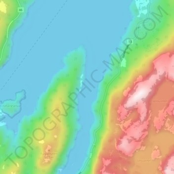
Name: Lovrafjorden topographic map, elevation, terrain.
Location: Lovrafjorden, Suldal, Rogaland, Norway (59.40843 6.20488 59.45682 6.22390)
Average elevation: 221 m
Minimum elevation: -2 m
Maximum elevation: 770 m
Other topographic maps
Click on a map to view its topography, its elevation and its terrain.
Vassfjellet
Vassfjellet, Sandbakk, Sandnes, Rogaland, 4309, Norway
Average elevation: 124 m
Store Stokkavatn
Store Stokkavatn, Eiganes og Våland, Stavanger, Rogaland, Norway
Average elevation: 21 m