
Ålgård topographic map
Interactive map
Click on the map to display elevation.
About this map
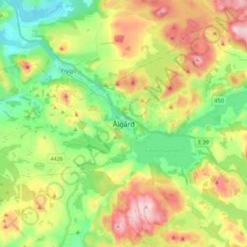
Name: Ålgård topographic map, elevation, terrain.
Location: Ålgård, Gjesdal, Rogaland, 4330, Norway (58.72921 5.80724 58.80921 5.88724)
Average elevation: 175 m
Minimum elevation: 40 m
Maximum elevation: 378 m
Other topographic maps
Click on a map to view its topography, its elevation and its terrain.
Vassfjellet
Vassfjellet, Sandbakk, Sandnes, Rogaland, 4309, Norway
Average elevation: 124 m
Store Stokkavatn
Store Stokkavatn, Eiganes og Våland, Stavanger, Rogaland, Norway
Average elevation: 21 m